Saltash Crossing
- Gethin Thomas

- Feb 27, 2025
- 18 min read
Saltash history is almost exclusively involved with it being the crossing point of the river Tamar between southern Devon and southern Cornwall. There are other crossing points like the Torpoint ferry which is still operational, the railway viaduct at Calstock, and the medieval bridge at Gunnislake which all cross the Tamar too, but Saltash by its geographical nature of being a narrow point has always been a favoured crossing point, first by ferry and today by both rail and road. For more on the Calstock viaduct and Gunnislake bridge see my earlier post here.

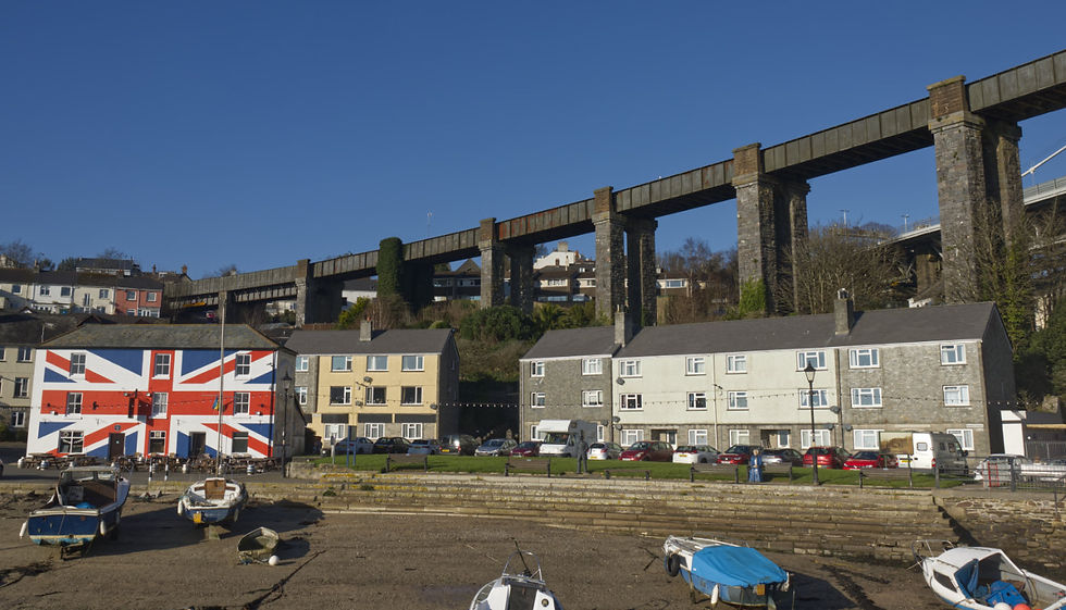
This narrow point on the river is also hemmed in by steep sided hills on either side which actually make high level bridges easier to approach. The two bridges here, side by side, were built 102 years apart. The first was the rail bridge of 1859, the brainchild of Isambard Kingdom Brunel, with its distinctive bow shaped supports. It is an early marvel of metal engineering and construction, and everything about it was state of the art and ground breaking. The second is the road bridge of 1961. Both have Royal connections. The earlier Royal Albert Bridge seen here named after Queen Victoria's late husband and the later Tamar Bridge opened by Queen Elizabeth the Queen Mother.

My earliest archive find was an advertisement for the sale of the ferry-house in 1809.
Royal Cornwall Gazette - Saturday 20 May 1809
Also. All that MESSUAGE or DWELLING-HOUSE, known by the sign of the PASSAGE or FERRY-HOUSE, situate within the said Borough of Saltash, in the possession of Glanvill, tenant thereof. For further particulars, apply to Francis Wills. Esq. in the Borough of Saltash ;
Crossing by ferry on a tidal river was always going to be more dangerous than using a bridge, especially when the ferry was a small boat operated by oars or ropes.
Star (London) - Tuesday 15 November 1825
PLYMOUTH, Nov. 12.—Nearly all Wednesday night, and the whole of the following day, we experienced a most terrific gale from N. W. to N.N.E. A fine fishing-boat got ashore at the back of the island—crew saved. All the shipping weathered the gale in safety. The horse ferry-boat at Saltash, together with many shore-boats, were washed off the beach, and lost.
This stone memorializes the ferry which ran here from time immemorial. This marker says it was here for 700 years while another says 1000 years, but as we know that there are Iron Age remains aplenty and Roman roads nearby so I think I will stick my neck out and say probably a lot longer than 1000 years. Certainly crossing the river would have been done here even if there were not a regular ferry service.

Just downstream at Torpoint a new steam boat ferry was on order in 1827.
North Devon Journal - Friday 16 March 1827
A steam-boat will be shortly established at the ferry between Devonport and Torpoint. The vessel which is now building at Neath, by Mr. Henry Price, will be flat-bottomed, and of sufficient capacity to receive the Cornish mail, coach, horses, and passengers, which will then run direct from Fore-street instead of from Torpoint as at present.
Only three years after the storm sunk the Saltash ferry is the first mention I have found of the plan to build a bridge.
North Devon Journal - Thursday 17 January 1828
BRIDGE ACROSS SALTASH FERRY - We understand that Mr. Hopkins being solicited by several gentlemen in Cornwall and this neighbourhood, to bring forward a scheme for erecting a bridge across the ferry at Saltash, he has pledged himself to do so before Lady day next. It is desirable that this measure should be carried into execution, and from the success of similar undertakings by Mr. Hopkins, in Teignmouth, and other places, we are induced to think it will.
In 1812 the painter Turner was showing his painting of the ferry slipway at Saltash.
Sun (London) - Tuesday 09 June 1812
THE ARTS.—Mr.TURNER opened his Gallery for admission of his friends a few weeks ago, and it was closed on Saturday last. Some of the Pictures had been submitted to the public before, and there are seven additional landscapes, all of which display extraordinary merit. Indeed we are almost disposed to say, that they even excel his former productions, except in two or three instances. Among the new works are The River Plym, Calder Bridge, Cumberland, Teignmouth, Saltash, with the Water Ferry, Ivybridge Mill, Devonshire, St. Maws, at the Pilchard season. All these pictures are painted with a boldness, vigour, and truth, which entitle the Artist to a very high station among the Landscape Painters of any period.......

Proof of very early use of Saltash as a crossing point comes from an early archaeological account of the Fosse Way remains, a Roman Road, that ran from Exeter to Lincoln. The route continued south west from Exeter to Land's End, via Plymouth.
Exeter and Plymouth Gazette - Saturday 08 August 1829
ANTIQUITIES.
NEAR PLYM-BRIDGE, DEVON. A continuation of the great Roman fosse-way extends from Totnes to the Land's End. From Ridgeway, in the parish of Plympton St. Mary, which doubtless owes its name to its situation, it pursues its course through the Earl of Morley's estate, and crosses the Plym at Plym Bridge; there ascending a steep hill, it passes over Egg-Buckland Down, whence Borlase traced it to within a short distance of Saltash Ferry.........
JOSEPH CHATTAWAY.

An early proposal for a road bridge never made it.
Exeter and Plymouth Gazette - Saturday 26 June 1830
DEVON & CORNWALL GRAND JUNCTION BRIDGE.
PROSPECTUS.
THE Inhabitants of the Counties of Devon and Cornwall, as well as Travellers to and from the West of England, have long experienced the great inconvenience and delay of crossing the Tamar River, by means of Boats at Saltash Ferry, which, in stormy weather, is attended with great danger, and is frequently impassable. To remedy this, several plans for building a bridge across the River at Saltash have been submitted to the Public, but have been abandoned in consequence of the difficulty of raising the large sums required for their execution. The great width and depth of the water way in the River at Saltash, at low water, being serious obstacles to the erection of Bridge at that place, I have recently examined the river above Saltash, and am convinced that a Bridge near Landulph is perfectly practicable, and can be executed for a sum which will warrant the expectation of profitable return for the capital invested and, from a view of the country on both sides of the River, am also confident that excellent Roads can be made to communicate with this Bridge......
The lower reaches of Saltash on the river are a spectacular spot if you wonder at bridges.

......The plan I have to propose is, to build a Bridge from Budshead Point, in the parish of St. Budeaux, in the county of Devon, to or near Nail Point, in the parish of Landulph, in the county of Cornwall.
The whole width of the River, at high water, is 3,211 feet; and, commencing at or near Nail Point, I propose to make the Bridge and approaches in the following manner :
Length of Embankment on the Landulph side of the river, as per plan and elevation 694 ft.
Eleven cast-iron Arches, supported on cast-iron columns, and a Swing Bridge on Stone Piers; the centre Arch to be 55 feet above low water mark, and the Platform to be of Cast iron, covered over with clay and broken stones to form the Road-way. 890 ft.
Embankment to extend to Budshead Point 1627 ft- Total 3211 ft.
The breadth of the carriage-road is proposed to be 17 feet, and a foot-path of 3 feet 6 inches wide to be on each side; making the whole breath between the railing 24 feet.
By the plan now proposed the navigation of the River will not be obstructed, since vessels of 500 tons burthen, even more, can pass through the Swing Bridge.......

.....The expenses of the erection of this Bridge (calculated at the present prices of iron and other materials, and labour,) the building aToll House, the obtaining of an Act of Parliament, and other incidental charges, I estimate at a sum not exceeding £30,000. (Today, just over £2 million)
To obtain Funds for the payment of Interest on the Capital embarked, it is proposed to apply to Parliament, not only for permission to take tolls for all foot-passengers, carriages, horses, and other cattle passing over the bridge, but also that an additional duty of one penny per letter should be charged upon all letters which may be conveyed over this Bridge, to be paid to the Bridge Company, towards increasing their annual income; and when the great importance of this Bridge is taken into consideration, there is great reason to believe that Parliament will assent thereto.......

The article continues with a fascinating list of the estimated traffic expected per week to use the new road bridge. 19 carriages a week and 144 carts. It is currently 38,200 cars per week on the 1961 road bridge rising to 43,000 per week in the summer.
....It is impossible to state with certainty the amount of Tolls which will be collected at this Bridge, but, from the inquiries which have been made, it is very probable that they will amount to the following sums per week.
Foot Passengers 150 - 2d.
Horses, Mules, and Asses carrying not more than one person, & not drawing 250 -4d.
Carriages drawn by two Horses 12 - 2/6
Carriages drawn by four Horses 7 - 4/
Cars and Gigs drawn by one Horse 28 -1/6
Carts drawn by one Horse 70 - 1/
Carts drawn by two Horses 60 - 1/6
Carts drawn by three Horses 14 - 2/
Waggons drawn by four Horses, or less 12 - 4/
Waggons drawn by six Horses 1 - 6/
Oxen, Cows, and other Neat Cattle 140 - 1/
Calves, Sheep, Lambs, or Pigs 260 - 2d.
Passengers in Carts and Waggons except the Drivers 70 - 2d.
Total £1677 17/4 per annum (Today £113,702 )
If this Bridge is executed, new roads will of course he made to communicate with it....
Independently of these advantages, the roads will be much more level than they could be via Saltash. ROGER HOPKINS, Civil Engineer,Plymouth, 3rd April, 1830.

So that bridge never got off the ground or over the river. By 1833 though there was a new "floating bridge".
Liverpool Albion - Monday 11 February 1833
OPENING OF THE SALTASH FLOATING BRIDGE.
(FROM THE DEVONPORT TELEGRAPH.)
On Thursday last this excellent accommodation was publicly established on the waters of the Tamar, for the conveyance of passengers, goods, cattle, carriages, &e., from and to the Devon and Cornish margins of the river. A bridge of the Saltash Ferry had long been ardently desired by the public, and an endless variety of plans, propounded by the influential gentlemen in the vicinity, had proved abortive. To hit upon an expedient which should perfect the land conveyance between the two counties, without interfering with the navigation on the river, and the restrictions of Government, was given up as hopeless—still, from the spirit of enterprise, (the river Dart having first become tributary,) the Tamar at last yields to science and the arts. The easy distance to Saltash will, doubtless induce many of the inhabitants of these towns to drive or walk to the ferry, to view this new species of amphibii.........

......The float forms a parallelogram of about 50 feet by 30 feet, open at both ends; the centre is occupied by two engines of six-horse power each, boxed over from end to end, so as to be entirely concealed externally; the engines work two wheels, on which rest two chains, which are laid from shore to shore; and traverse through the engine-room. On either side the engine-room is a clear space of 50 feet by 10, for carriages, horses, cattle, and foot-passengers. Carriages of every description are run in and out, without detaching the horses, and the passage is accomplished in five minutes. The prows or platforms for shipping and landing are four in number, two at each end, each 21 feet long by 10 in width. They are so arranged as to drop on the shore and form almost a level platform. New landing-places are formed on the sides of the river, with an easy inclination to facilitate the embarkation.

The above was planned and executed by Mr. Kendle, the engineer, who constructed the floating bridge at Dartmouth. A construction of this kind appears well adapted for the passage of the Mersey, at Runcorn Gap. Indeed, we should not be surprised, if, under skilful hands, something of this kind might not be made applicable to the passage of the river above our docks.—Such a circumstance would still more closely unite the two shores.—Ed.
In fact so successful was this crossing model mentioned at Dartmouth, that a version of it is still the main crossing of the lower Dart to this day.

The idea of a road bridge having been abandoned and the new steam floating bridge proving a huge success, minds now moved to the idea of a railway bridge, which would link Cornwall to the rest of the country. Torpoint or Saltash?
In June 1846 a hearing was held for planning the Cornwall Railway. Much debate was made regarding the position of any new bridge and the route to be taken by the rails themselves. Britain was not at peace so there was some concern that the railway were not placed too near the coast for fear any enemy could easily breach it in an invasion. Strategically a bridge needed to be further inland, for this reason, and also so as not to impede naval shipping at the nearby Devonport Docks on the Tamar.
One witness proposed a line running along the centre of the south west peninsula, away from both coasts. Another witness familiar with the port at Plymouth claimed to have seen up to twenty merchant ships approaching the harbour at the same time, so busy was the shipping. If windy, navigation was more difficult and the existing floating bridge at Torpoint regularly had to stop running at high tide to allow shipping to pass.
The proposed bridge at Saltash would be a serious obstruction to the navigation of the river. The witness considered it so serious that he could not conceive that it would be permitted by the Admiralty. The estimate given by the promoters of the bill for this bridge (£40,000) was insufficient ; it would cost at least £150,000. It was most desirable for Falmouth and Cornwall generally to have a direct central communication with London.
The Admiralty made sure to send its own witnesses to the hearing. You will now see why the bridge that was built was so high and why Saltash was chosen above Torpoint.
Mr. Walker, the harbour master at Plymouth, stated in examination that he also was a public witness attending the Committee by order of the Admiralty..... He considered that any piers, piles, or other erections on the banks of the Hamoaze would be extremely objectionable. The best communication would by a bridge of sufficient height, and wide span, at Saltash. Vessels of 240 tons went over the site on which the proposed bridge was to be built. The extreme height of the masts of these vessels would be from 80 to 90 feet. In order to pass under this bridge (which is proposed to be 70 feet high from the high water mark), they must strike their masts, an operation attended with difficulty and delay, where the crew is small. A bridge of the structure proposed would also interfere with the course of the river and tide. A bridge 90 feet high would not materially obstruct the passage of vessels.

Saltash won the argument but the Admiralty would have the final say on the height of the crossing. It could take 8 or 9 hours for a ship's crew to reset a lowered mast so a lower bridge was a non starter.
This bridge was to be a first, and therefore the techniques to build it were not yet discovered. The first part of the project was working out how to actually build it.
Royal Cornwall Gazette - Friday 26 January 1849
THE PROPOSED RAILWAY BRIDGE AT SALTASH.
Some interesting proceedings took place on Wednesday, in connection with the bridge across the Tamar at Saltash, projected for the traffic of the Cornwall Railway...... The company assembled, having got on board the brig moored in the middle of the river off Saltash, their attention was first directed to the gigantic cylinder six feet in diameter, and 85 in length, which, resting on the solid rock at the bed of the river, reared its head out of the water, like the funnel of a steam vessel, on an enlarged scale. Down this tube most of the parties present were lowered, (three at a time) and were thus enabled to judge for themselves as to the result of the operations. When all who felt a curiosity so to do had made the formidable descent beneath the bed of the river, Mr. Glennie (Engineer) read a statement of the circumstances connected with the construction of the bridge, from which we extract some interesting particulars : — The proposed bridge for carrying the Cornwall Railway across the river Tamar at Saltash, was required by the Act of Parliament obtained for the construction of the said railway, to have a clear width between the piers of not less than 300 feet and also a clear height of 100 feet above high water mark. The depth of water in the middle of the river is from 68 to 70 feet at high water, and the depth of mud covering the rock varies from about 10 to 17 feet. The width of the river in the line of the proposed bridge is 347 yards at high water and 286 yards at low water. The river being considerably narrower here than it is both above and below the town of Saltash, the tides flow with great rapidity both on the flood and ebb tide, but they seldom exceed two miles an hour at spring tides, and at the neap tides they sometimes lower their rate to 3/4 of a mile, and even less. It may here be stated that if the piers of the bridge should be so placed as to give only the 300 feet clear width required by the act of Parliament, two of the piers would have been placed in deep water, whereas by extending the opening to about 420 feet, one pier would be situated on the rock on the west shore, another nearly in the centre of the river, and the third just below low water mark on the east shore. By this arrangement only one pier would be in deep water.......

Having managed to limit the difficult job of building piers under water to just one pier, it was decided that a massive metal tube would be constructed, which would be floated to the correct location, where it would be tilted upright and lowered onto the river bed. This would then be emptied of water enabling the exposing to the air of the river bed itself where work to build the pier could then continue.
.......The cylinder was made of 5/8 inch boiler plates rivetted together like the boiler of a steam engine with a strong internal band of iron at intervals of 4ft. 6 inches throughout its length. It is 6ft. in diameter and 85 feet long, and weighs 28 tons. It was brought to Saltash from Bristol in 4 lengths, which were rivetted together on a wharf at the former place. When ready, a flat wrought iron cover with a stop cock in it was screwed down on the top and a wooden head put into the bottom end so as to exclude the water. It was then rolled off the wharf into the water and towed to the brigs. The purchases having been made fast, the upper end was lifted sufficiently high to allow the lower end to clear the mud, on obtaining an upright position. A hawser having been previously fixed to the wooden head, it was then hove out and the cylinder gradually assumed an upright position, the air confined within it being sufficient to float it and slacken the purchases attached to the upper end. The stop cock in the top cover being then opened to allow the air to escape, it sank gradually into the mud in the required position. The cover being removed, the capability of the cylinder to serve as a cofferdam, was at once proved by drawing all the water out with a large iron bucket, which had been provided for the purpose. The surface of the mud was exposed to view, and the leakage was so small, that on leaving off drawing the water, it only rose at the rate of 13 inches in an hour......

This tube was then refloated and moved 35 times so that the river bed could be examined and borings made to ascertain where the rock was and the nature of the rock.
.....a series of borings were commenced, and carried on until the level of the rock was ascertained, over a surface of 50 feet square. During these operations the cylinder was moved 35 times and 175 borings were obtained. The level of the rock on the east shore (a little below low water) was also examined by borings without the aid of the cylinder, and found to be most favorable. Over a surface of 66 feet square, the level does not vary so much as one foot, the depth of mud covering the rock varying from 8 to 18 feet— The requisite number of borings having been obtained, it now remained to excavate down to the rock within the cylinder, in order to examine its nature, and also to ascertain whether any flow of water, or any hitherto unknown difficulty, might present itself.....
Here is the great man himself, nearly always portrayed with his iconic cigar, with one of his most famous constructions high above him. Isambard Kingdom Brunel.

It was ascertained that the weight of the iron tube took it's base to within 18 inches of the solid rock. The mud at the bottom of the river changed with depth starting very soft before changing to a compacted and seashell containing hard mass about 8 feet down. To prevent any inrush of matter or water as the rock layer was reached, due to the 18 inch gap at the base of the tube, 6 inch wide oak planks were driven down the sides of the tube as it was excavated, these being reinforced as the bottom was reached, by an iron band. The rock base was then excavated by another three feet, whereupon it was decided that the rock was capable of sustaining the weight of masonry that would be placed on it.
Astonishingly, all of this was just preliminary work to establish the feasibility and cost. The masonry layer was built up by three feet to form the base of the new pier. The depth of mud was filled with clay to level off the river bed and the steel tube floated away to the river bank. All they needed now was the rest of the money to actually build it.
....An important point in engineering science is established by the result of these experiments, viz., the adaptation of the cylinder for furthering operations in deep water. All those connected with the undertaking deserve the greatest credit for their exertions. The genius of Mr. Brunel needs no acknowledgment......
....A copper-plate, enclosed in a copper case, will be deposited in the masonry, which will be built upon the rock at the bottom of the river. It will bear the following inscription : "Cornwall Railway, Saltash Bridge. Trial foundation of Centre Pier. Jany. 1840. I. K. Brunel, engineer : Wm. Glennie, resident do."....

Francis's Metropolitan News - Saturday 05 March 1859
The Royal Albert Bridge, Saltash.
The Royal Albert Bridge of the South Devon and Cornwall Railway Company, which spans the Tamar at Saltash, is one of the most stupendous efforts of engineering science of which the age can boast.......an accomplishment of the scientific enterprise of the age and it will remain to posterity as a monument of the wealth, enterprise, and civilisation of Great Britain, more remarkable, because far more useful, than the Pyramids.

Under the bridges and around the old ferry slipway are various monuments, including the statue to Brunel that we have already seen. There is also a contemporary sculpture in memory of the early ferry boats. These stopped running when the new road bridge opened in 1961. This sculpture is called "The Saltash Ferryman" by John Forster.
'The Saltash Ferryman' sculpture at the waterside represents all the ferrymen and women who have worked the ferries over the centuries. It celebrates 900 years of crossing the River Tamar. The sculpture was designed by John Forster and incorporates brass panels etched by ten Saltash artists, illustrating the story of the ferries over the centuries, together with memories of the last generation who recall using the ferry, before it was replaced by the road bridge in 1961. artuk.org

The railway that operates today still bears the name of Brunel's original railway company, Great Western. The first main span was positioned in 1857 and the completed bridge was opened by Prince Albert on 2 May 1859. Brunel died later that year and his name was then placed above the portals at either end of the bridge as a memorial. During the 20th century the approach spans were replaced, and the main spans strengthened. It has attracted sightseers since its construction and has appeared in many paintings, photographs, guidebooks, postage stamps and on the UK £2 coin. Wikipedia

Back at the start of this piece, mention is made of Mr. Glanville, the tenant of the Ferry House.
Ann Glanville (1796–1880) was a Cornishwoman who achieved national celebrity for rowing a four-oared watermen's boat.Born in Saltash in Cornwall as Ann Warren or Warring, she married John Glanville, a waterman from a line of watermen. They had fourteen children and when John fell ill, Ann continued her husband's trade to support the family. Ann formed a crew of four female rowers who took part in local regattas; she was noted for her large stature and for her crew who dressed in white caps and dresses. Their success led to competitions all over the country; one event at Fleetwood was watched by Queen Victoria, who congratulated Ann when they won by beating an all-male crew.

During the 20th century, there was increasing demand to replace or supplement the Saltash and Torpoint ferries, which could not cope with the rise in motor traffic. The Government refused to prioritise the project, so it was financed by Plymouth City Council and Cornwall County Council. Construction was undertaken by the Cleveland Bridge & Engineering Company and began in 1959. It was unofficially opened in October 1961, with a later formal presentation by Queen Elizabeth The Queen Mother in April 1962. Wikipedia

A reconstruction of the bridge began in 1999 after it was found to be unable to support a European Union requirement for goods vehicle weights. The work involved building two new parallel decks while the original construction was completely rebuilt. The project was completed in late 2001 and formally opened by Princess Anne in April 2002. The extra decks have remained in use, increasing the bridge's capacity.

The total cost of the bridge was £1.8 million (today £51 million). It was the first major suspension bridge to be constructed in the UK after World War II, and the longest suspension bridge in Britain.

On 23 January 2004 four protesters climbed onto the gantry over the Tamar Bridge to highlight the work of the group Fathers 4 Justice who promote the rights of fathers in child custody disputes. The protest caused rush-hour tailbacks on both sides of the bridge. Charges against the protesters were later dropped after it was felt there would not be a realistic chance of conviction.

Standing here where the river is so narrow you can appreciate why it is the natural crossing point because looking only a few hundred yards downstream it is a different story, with the river being many times wider and problematic.


Comments